Click a keyword in red to see the explanation(in Japanese).
Oceans account for 70 percent of the earth’s surface, and they greatly affect the global environment. Some obvious examples of this are El Nino and global warming. However, due to their vastness, the actual conditions in the ocean are not fully understood. Moreover, since ocean data ranges from ripples with a wavelength of a few centimeters to fluctuations extending tens of thousands of kilometers, special data analysis is needed to extract information effectively.We analyze in-situ observation data such as that from ship observations and mooring observations, as well as drifting buoy data and satellite observation data, and discover new, observable facts related to the variation characteristics of the ocean. Then, based on our findings, we study the role of the ocean in global environmental variation.
In-situ observations (ship observations and mooring observations) allow us to make concentrated measurements, but measured times and locations are limited. On the other hand, satellite observation allows us to monitor a large area repeatedly, but the measurement is only done at the marine surface layer. In addition, the physical quantity cannot be measured directly. Therefore, we need to form some hypothesis. In order to fully exploit the advantages of both forms of observation, we are studying a method of integrating the data and extracting information (Fig. 1).
The Kuroshio is one of the strongest currents in the world, carrying a huge amount of seawater from south to north. It plays a vital role in redistributing the heat of the North Pacific. We conduct in-situ observations including ship and mooring observations at the observation line that runs across the Kuroshio and the Kuroshio countercurrent in cooperation with many research laboratories in Japan and abroad (Fig. 2). The in-situ observation data and the satellite altimeter data are integrated to evaluate how heat and water are carried in the North Pacific (Fig. 3). We also study what factors contribute to the fluctuation of the Kuroshio based on the fluctuation of the wind stress in the entire North Pacific.⇒⇒⇒ Time series of the Kuroshio transport along the ASUKA line
Many of the fluctuations of the marine surface layer slowly spread to the west as a huge disturbance called a mesoscale eddy. While spreading, eddies diffuse peripheral materials effectively and move the water mass as well. Analysis of the satellite data enables us to evaluate the influence that the eddies have on the surrounding ocean area (Fig. 4). We can thus make concrete estimates of the effect of mesoscale eddies on the coastal area in Japan and other regions. In addition, we aim to clarify the propagation characteristics and the source of the eddies, and to make use of the research results for long-term ocean predictions.
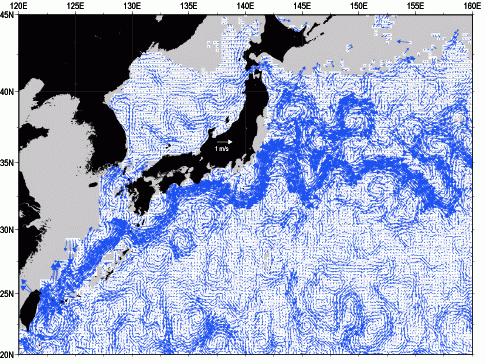
Fig. 1: Surface velocity field as of December 10, 1998, acquired through the integration of the drifting buoy data and satellite altimeter data. There is a swath of Kuroshio that flows quickly just in the south of Japan and meanders off the coast of Izu. In addition, many mesoscale eddies, which are about as big as Hokkaido and Kyushu, can be observed. Since this image can be created about every ten days, it is useful to track the time-series evolution of the features of the Kuroshio and the mesoscale eddies.
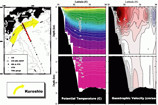
Fig. 2: Cross-sectional views of the Kuroshio observation line off the coast of Shikoku (left), the water temperature of the red line (center) and the geostrophic velocity (right). In the image on the right, the reddish-colored parts show the flow velocity going toward the east from the west. By computing the velocity per area integral, the volume of the seawater that the Kuroshio transports is shown to be about 50×106 m3/sec. This is the equivalent of 25 Fukuoka Domes filled with seawater passing the traverse line each second.
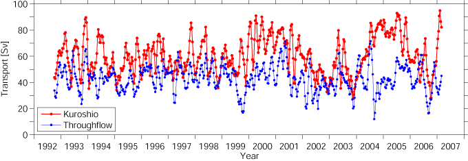
Fig. 3: Time series of the flow volume of the eastward flowing Kuroshio above 1000 m (red line) when crossing the Kuroshio observation line (Fig. 2) off the coast of Shikoku, and the throughflow of the Kuroshio (blue line) (Unit: Sv = 106 m3/sec). The graph is created by the integration of the in-situ observation data and the satellite altimeter data. Various changes over periods ranging from a few weeks to several years can be observed.
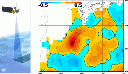
Fig 4: Pattern diagrams of the sea surface height measured by satellite altimeter (left). The data for the sea surface height is used to obtain the distribution of the correlation coefficient with the tidal variation of Naha (right). The tidal variation of Naha extends across a vast sea area covering the whole of Kyushu, and so the correlation is found to be high. In addition, it is observed that the western sides of the Ryukyu Islands are larger due to the influence of the Kuroshio.